Floods, Wildfires and Other Natural Disasters: How Emerging Tech Keeps People Safe
August 20, 2021
In a typical year, insurers, governments and individuals spend billions of dollars responding to natural disasters.
In the first half of 2021, wildfires have displaced thousands of people in the U.S. In China, one year’s worth of rain fell in 72 hours in the city of Zhengzhou, causing massive flooding that killed dozens.
The response has put enormous pressure on emergency personnel. Stretched thin, and in some places running from one disaster to the next, they’re risking their lives to rescue people in unpredictable environments.
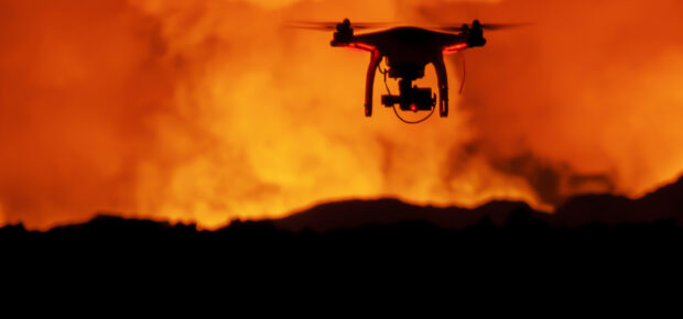
Emerging technologies, like low-cost satellites, robotics and machine vision can make first responders’ jobs safer and help them make faster decisions on where to deploy resources.
Reducing Risk and Mapping Cluttered Environments
IEEE Senior Member Ella Atkins looks forward to a day when autonomous systems, from robots to aerial drones can help first responders avoid risk. That includes two-legged and four-legged robots to help dig trenches and carry materials into wildfire zones — something that humans do now.
And unmanned aerial vehicles may help detect small wildfires in remote locations.
“Early detection of wildfires will reduce required manpower because the fire will be smaller and easier to contain,” Atkins said.
Her research team is helping to lay the groundwork in these areas, with recent work that has focused on the use of autonomous aerial vehicles for fire boundary mapping, algorithms to help autonomous vehicles navigate cluttered areas and technologies that will guide teams of autonomous aerial drones in disaster areas so they can deliver food, water and other materials.
Helping Rescuers See Through The Haze
Since 2016, IEEE-MOVE, an IEEE-USA initiative, provided internet access (and cell phone charging) to first responders and community members in the immediate aftermath of major disasters. These temporary emergency relief provisions help those affected stay connected and make sure they can access the help they need.
Recently, Karen Panetta, an IEEE Fellow, partnered with the organization’s mobile disaster response team to add a new capability that enhances the ability of first responders to see hazards and people who may need rescue.
Rescuers often depend on video or images to help them identify areas of interest in a disaster. But fog, smoke, fire or damaged buildings and debris often make it hard to spot certain details. Working with IEEE member Mary Ellen Randall, Panetta developed a system to combine that with other sensor data, like thermal imaging, and to process that sensor data with artificial intelligence. The technology allows first responders to better identify potential hazards in chaotic situations.
On the Horizon: Swarms of Small Satellites
Expensive, large-scale Earth observing satellites have been in orbit for decades — and they’ve been used for weather forecasting and some disaster response. These satellites have offered comprehensive imagery of Earth’s atmospheric and surface features. But because they are expensive to build and operate — they often have massive ground support teams — they have always been relatively scarce. For first responders, there may not be a satellite available to offer constant “eyes in the sky.”
Atkins sees one area of enormous promise: Low-cost, lightweight cubesats (some may be as small as a loaf of bread) launched into lower-altitude orbits. Many of these satellites have limited to no ground station supervision requirements, making them less expensive to build and operate, which in turn enables continuous monitoring of specific sites — like wildfires and floods.
Despite their tiny size, cubesats can pack enormous processing power, including onboard AI image processing that can identify interesting features before humans can.
At the heart of the matter, natural disaster response is about saving human lives and property, but the ability to do that is dependent on responders’ ability to understand the disaster and the area it impacts. New technology gives first responders, along with the drones and robots they’ll use in the future, new data that they can use to see from different vantage points like space. By integrating more data, they can deliver relief faster and more effectively — and they’ll be saving lives in the process.


 Liquid Infrastructure: Our Planet's Most Precious Resource
 The Impact of Technology in 2025
 Quantum and AI: Safeguards or Threats to Cybersecurity?
 Why AI Can't Live Without Us
 Bits, Bytes, Buildings and Bridges: Digital-Driven Infrastructure
 Impact of Technology in 2024
 Emerging AI Cybersecurity Challenges and Solutions
 The Skies are Unlimited
 Smart Cities 2030: How Tech is Reshaping Urbanscapes
 Impact of Technology 2023
 Cybersecurity for Life-Changing Innovations
 Smarter Wearables Healthier Life
 Infrastructure In Motion
 The Impact of Tech in 2022 and Beyond
 Cybersecurity, Technology and Protecting Our World
 How Technology Helps us Understand Our Health and Wellness
 The Resilience of Humanity
 Harnessing and Sustaining our Natural Resources
 Creating Healthy Spaces Through Technology
 Exceptional Infrastructure Challenges, Technology and Humanity
 The Global Impact of IEEE's 802 Standards
 Scenes of our Cyber Lives: The Security Threats and Technology Solutions Protecting Us
 How Millennial Parents are Embracing Health and Wellness Technologies for Their Generation Alpha Kids
 Space Exploration, Technology and Our Lives
 Global Innovation and the Environment
 How Technology, Privacy and Security are Changing Each Other (And Us)
 Find us in booth 31506, LVCC South Hall 3 and experience the Technology Moon Walk
 Virtual and Mixed Reality
 How Robots are Improving our Health
 IEEE Experts and the Robots They are Teaching
 See how millennial parents around the world see AI impacting the lives of their tech-infused offspring
 Take the journey from farm to table and learn how IoT will help us reach the rising demand for food production
 Watch technical experts discuss the latest cyber threats
 Explore how researchers, teachers, explorers, healthcare and medical professionals use immersive technologies
 Follow the timeline to see how Generation AI will be impacted by technology
 Learn how your IoT data can be used by experiencing a day in a connected life
 Listen to technical experts discuss the biggest security threats today
 See how tech has influenced and evolved with the Games
 Enter our virtual home to explore the IoT (Internet of Things) technologies
 Explore an interactive map showcasing exciting innovations in robotics
 Interactively explore A.I. in recent Hollywood movies
 Get immersed in technologies that will improve patients' lives