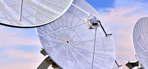
Satellites: The View From Above, Protecting Infrastructure
January 25, 2023
Climate change has made natural disasters – like wildfires, hurricanes and floods – more frequent and more severe. And that poses a risk to infrastructure.
For planners and engineers, that makes new monitoring tools an imperative. And increasingly, these tools are being used to decide where infrastructure is built.
“We know that infrastructure will have to cope with disasters by being more robust and resilient, and also monitored 24/7 intelligently,” said Tiago Nascimento, IEEE member. “This is mandatory since the threat to infrastructure is rising due to the growth of the strength of the natural disasters climate change is bringing every year.”
Climate-Resilient Infrastructure
The list of ways that disasters challenge infrastructure is long.
Wildfires, whipped up by high winds, can damage power lines which, in turn, can spark new fires. Utilities in areas prone to wildfires have started burying power cables and hardening structures in response. Satellite data, meanwhile, is used to predict the potential risk and paths of wildfires to help inform how firefighting resources are allocated and, in rare instances, preemptively turn off power to some locations.
Floods, which rank among the costliest natural disasters, are more common in coastal areas due to rising sea levels. Before storms occur, companies plan for major flooding with satellite mapping tools that tell them which pieces of critical infrastructure – from power stations to telecommunications facilities – might be at risk over a 30- or 50-year period.
Hurricanes can damage bridges and roads, cutting off evacuation routes for civilians, making it harder for first responders to reach survivors. And many coastal cities are changing building codes to ensure resilience.
“When Hurricane Sandy hit New York in 2012, several utilities reconsidered where systems and backup systems are installed in facilities. Basement levels are no longer viable,” said IEEE Senior Member Paul Kostek.
The Cutting Edge
Advances in satellite technology are mapping the earth’s surface to assess changes – sometimes down to the millimeter.
“Interferometric synthetic aperture radar (InSAR) is now a very powerful tool to monitor the displacement of infrastructures, which would enable early warning of risks,” said Feng Xu, IEEE Senior Member.
In one recently published paper, researchers examined the rate of ground subsidence in the coastal city of Tianjin in China. Ground subsidence means that ground is sinking relative to other geographic features, and there can be a number of causes, including the removal of groundwater. Researchers used InSAR data to determine that the rate of subsidence in downtown Tianjin had slowed to 8mm per year after the installation of a major water pipeline. That rate marked a major decline from previous years when the ground had been shrinking by as much as 110mm per year.
Subsidence has become a major cause for concern in many cities across the world, in part because it exacerbates the risk of sea level rise. When the ground shrinks at the same time that seas are rising, the risk of flooding is greater.
InSAR is also being used to monitor earth surface deformation, and thus it can also be used to guide the selection of the site for construction of major infrastructure projects, Xu said.
And satellite observation is getting better – with researchers working with artificial intelligence and machine learning to identify the effects of natural disasters faster, more accurately and at a finer resolution.
Learn More: Integrating renewable energy into electricity grids is a key challenge for grid operators. The experience of grid operators in Tasmania, an island off the coast of Australia with abundant sources of renewable energy, presents a fascinating case study with global lessons. If you’d like to learn more, check out this article from IEEE Electrification magazine.
Interested in becoming an IEEE member?
Related Stories

Artificial Intelligence (AI) | 3 weeks ago
What the Future Holds for Computer Science and Tech Graduates

Artificial Intelligence (AI) | 4 weeks ago
Machine Learning Is Bridging the Gap in Mental Health Services


 Liquid Infrastructure: Our Planet's Most Precious Resource
 The Impact of Technology in 2025
 Quantum and AI: Safeguards or Threats to Cybersecurity?
 Why AI Can't Live Without Us
 Bits, Bytes, Buildings and Bridges: Digital-Driven Infrastructure
 Impact of Technology in 2024
 Emerging AI Cybersecurity Challenges and Solutions
 The Skies are Unlimited
 Smart Cities 2030: How Tech is Reshaping Urbanscapes
 Impact of Technology 2023
 Cybersecurity for Life-Changing Innovations
 Smarter Wearables Healthier Life
 Infrastructure In Motion
 The Impact of Tech in 2022 and Beyond
 Cybersecurity, Technology and Protecting Our World
 How Technology Helps us Understand Our Health and Wellness
 The Resilience of Humanity
 Harnessing and Sustaining our Natural Resources
 Creating Healthy Spaces Through Technology
 Exceptional Infrastructure Challenges, Technology and Humanity
 The Global Impact of IEEE's 802 Standards
 Scenes of our Cyber Lives: The Security Threats and Technology Solutions Protecting Us
 How Millennial Parents are Embracing Health and Wellness Technologies for Their Generation Alpha Kids
 Space Exploration, Technology and Our Lives
 Global Innovation and the Environment
 How Technology, Privacy and Security are Changing Each Other (And Us)
 Find us in booth 31506, LVCC South Hall 3 and experience the Technology Moon Walk
 Virtual and Mixed Reality
 How Robots are Improving our Health
 IEEE Experts and the Robots They are Teaching
 See how millennial parents around the world see AI impacting the lives of their tech-infused offspring
 Take the journey from farm to table and learn how IoT will help us reach the rising demand for food production
 Watch technical experts discuss the latest cyber threats
 Explore how researchers, teachers, explorers, healthcare and medical professionals use immersive technologies
 Follow the timeline to see how Generation AI will be impacted by technology
 Learn how your IoT data can be used by experiencing a day in a connected life
 Listen to technical experts discuss the biggest security threats today
 See how tech has influenced and evolved with the Games
 Enter our virtual home to explore the IoT (Internet of Things) technologies
 Explore an interactive map showcasing exciting innovations in robotics
 Interactively explore A.I. in recent Hollywood movies
 Get immersed in technologies that will improve patients' lives